
Yellowhead County issues 2nd wildfire evacuation order
County also expanded the affected area of a previous evacuation order

More Yellowhead County residents had to leave their homes Friday, after the county issued a new wildfire evacuation order for two communities and expanded an existing order.
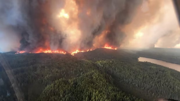
Shortly before 8:30 p.m. MT Friday, the county told people living in the communities of Mercoal and Robb — each roughly 240 kilometres west of Edmonton — they have to flee. An out-of-control fire, that spanned 400 hectares around 9 p.m. MT Friday, burns just west of the communities, according to Alberta Wildfire's dashboard.
Firefighters have finished installing a sprinkler protection system in Mercoal and are setting up sprinklers in Robb and Peers, according to a Facebook post from Yellowhead County Saturday morning.
The hamlet of Peers was affected by a separate evacuation order Thursday, because of a wildfire just south of the community, about 100 kilometres northeast of the Mercoal fire.
But on Friday evening, the county had to expand the area affected by that order because the fire had grown to 1,400 hectares as of 9 p.m., the wildfire dashboard shows. The map suggests the fire has blocked off part of Highway 32 that connects to Highway 16, a major thoroughfare that runs from Jasper, Alta., through Edmonton, to Lloydminster, Alta.
Anyone living 1.6 kilometres — one mile — west of Highway 32 and north to McLeod River has to leave, the updated order says.
As of 10 a.m. Saturday, 61 total active wildfires are burning throughout Alberta, the wildfire dashboard shows. About 60 per cent are out of control.
"It's been challenging because we have so many fires spread across such a large geographic area," Derrick Forsythe, provincial information officer for Alberta Wildfire, told CBC News Network Saturday afternoon.
He did not have an estimate as to how many Albertans have had to evacuate their homes, he said.
Across the province, 800 firefighters are working on the various wildfires, he said.
The agency is in the process of accessing "resources" from outside Alberta, some of which are starting to arrive Saturday, Forsythe said.
Environment and Climate Change Canada's (ECCC) air quality health index, which measures how safe the air is to breathe, suggests there will be a moderate risk throughout most of the province this weekend. But in northeastern Alberta, the risk is expected to be very high.
The Red Earth East complex fire, a series of wildfires burning in the Slave Lake Forest Area in northern Alberta, is burning west of the Wood Buffalo region, according to the Alberta Wildfire dashboard.
Air in Cold Lake, Alta., near the Alberta-Saskatchewan border, is also expected to high to be very high risk this weekend, the air quality health index suggests.
The ECCC weather radar shows light rain moving northwest in the province, past places like Slave Lake. Forsythe said there is a chance of lightning with it, but they'll take the rain all the same.
"That will give us a chance to get around some of these fires, because they have grown to a point where it's going too long to get those guards built, get them circled, so we can start working and cooling them off at the edges," he said.
Fires close multiple highways: 511
The provincial traveller information service, 511 Alberta, is reporting that wildfires have shut down several highways in northern and western parts of the province.
The fire near Peers closed Highway 32, from Highway 16 to the intersection of Highway 748 and Township Road 552, according to 511 Alberta's map.
Portions of highways near the Mercoal fire are also closed. The closure runs from Highway 734, just north of Cadomin, Alta., through Highway 40 and 47, at McLeod River.
The Red Earth East complex, which forced the Municipal District of Opportunity No. 17 to evacuate the hamlet of Red Earth Creek, shut down Highway 686 as of Friday morning.
Highway 88 has been shut down since Thursday due to a fire nearby, which Alberta Wildfire estimated to cover about 10,500 hectares as of Saturday morning.
A large fire just north of Swan Hills, Alta., which triggered an evacuation order for the town about 180 kilometres northwest of Edmonton, has crossed Highway 33. The road, from Swan Hills to the intersection with Highway 2, has been closed since May 26.
With files from Natasha Fatah
