
Reversing Falls rock walk tells the stories beneath Saint John's feet
300 million years ago, Reversing Falls area was where ancient continents collided

Three hundred million years before Reversing Falls was home to a sea monster legend, a skywalk, two shiny new steel monopoles, and the Irving Pulp and Paper mill — it was the place where two ancient continents collided.
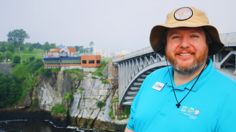
The area around Reversing Falls is the "heart of the Stonehammer Geopark," according to Patrick Sorensen, an interpreter with the UNESCO-designated site.

Although Stonehammer was designated in 2010, "not many people know what a geopark is in this region," he said.
Contrary to the name, it isn't a park.
Stonehammer is a set of 61 geologically significant places spread over a 2,500-square-kilometre area, from Norton to St. Martins, along the coast of the Bay of Fundy to Lepreau Falls and across to Grand Bay-Westfield.
Of those 61 sites, Reversing Falls is one of the most dramatic landscapes — and one of the most compelling stories of geological change.
The waterfalls that drowned
From the steep, rocky coastline of Fallsview Park, seagulls, cormorants, and herons can be swooping in and out of the rapids.
The three tiny islands in the St John River — Goat Island, Middle Island and Crow Island — are a popular nesting and feeding site for birds.
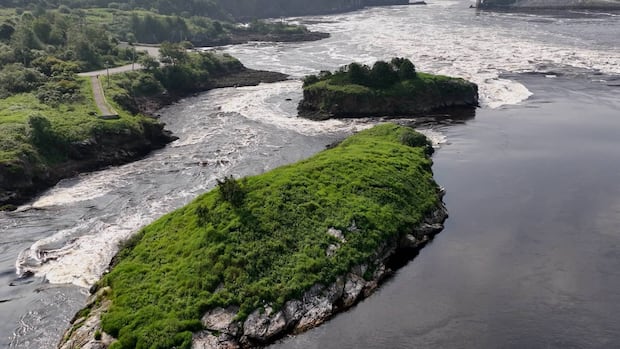
But 10,000 years ago, during the last ice age, the area around these islands would have been a "three-tiered waterfall," Sorensen said, created by the pushing and plowing of glaciers as they moved across the landscape.
As the ice age receded, the sea level rose and the riverbed was eroded, changing the path of the river. The towering waterfalls were slowly submerged beneath the surface.

But traces of them remain beneath the surface of the St. John River.
Just past the three islands, the riverbed drops a dramatic 25 metres into an underwater plunge pool. It drops again by an additional 40 metres just past Reversing Falls bridge, which is part of what causes the fierce Category 5 rapids and whirlpools for which Reversing Falls is known, Sorensen said.

Contrasting cliffs
About a kilometre away from Fallsview Park at Reversing Falls, a steep set of stairs beside the former 14½ Cafe and Bar leads down to a wooden observation platform surrounded in summer by wild roses.
Looking up from the deck, or across the gorge from the lookout at the top of Chesley Drive, It's clear to even the least geologically savvy observer that the cliffs are composed of two different types of rock.

The billion year-old light grey marble was smashed up against the darker grey shale and sandstone — which is a comparatively youthful 500 million years old — as an ancient ocean closed and the supercontinent Pangea formed some 480 to 430 million years ago.
"We can tell their ages by the fossils we find within them," Sorensen said.

Fossils of Cambrian-era trilobites — aquatic crabs or arthropods that live in the base of oceans — have been located in the shale and sandstone. Stromatolite fossils — stone formations formed by ancient cyanobacteria, among the first known life forms on Earth — have been found in the lighter marble.
Several of those fossils, Sorensen said, are on display at the geopark's seasonal Interpretation centre in the Area 506 Container Village.

Legends of the land
A short hike up another step of stairs to Wolastoq Park provides an opportunity to see how the Wolastoqey interpreted the geological features they observed in the land.
A carved statue of Glooscap and a giant beaver are accompanied by a plaque that relates the Indigenous origin story of Reversing Falls.

According to the tale, Beaver built a dam at the rapids that stopped the flow of water. Glooscap, the legendary hero of the Wabanaki, came down and "asked him three times to take down his dam, but Beaver does not do so," Sorensen said.
"So Glooscap takes his mighty club and swings and destroys the dam, smashing it," creating the chunk that appears to be missing from the base of the cliff on the eastern side of Reversing Falls Bridge.
"All these pieces floating out into the Bay rested as a small island off of the coast of our city, which is called Partridge Island."
Both the Wolastoqey legend and the geological explanation of the landscape involve "smashing and this rushing of water," Sorensen said, "just as the glaciers would have pushed up against the natural flow of the river, creating a dam, we have a big rush of energy happening in this story, too."
Understanding how Wolastoqey stories complement Western science, Sorensen said, is part of the notion of Two-Eyed Seeing: incorporating the strengths of Indigenous knowledge and those of Western knowledge, using both together to understand the landscape around us.

Science beneath our feet
New Brunswickers will have an opportunity to take in these perspectives in more detail at a guided hike next week around Reversing Falls.

Sorensen will be leading a group on Tuesday from 10 a.m. to 12 p.m. at Fallsview Park. Advance registration is required. While the spots are filling up, he said, people interested in the geological history of the region can book tours via Stonehammer's website.
New Brunswick is "one of the only places in the world where you have a continuous timeline of our geologic record almost all the way back to one billion years," Sorensen said.
"We're educating people about the geology and the beauty of the science that we have right underneath our feet."

ABOUT THE AUTHOR

