
Team investigates reports of possible tornadoes near Winnipeg
Northern Tornado Project members look for signs of damage from funnel clouds seen near Birds Hill, Dugald

Researchers are on the ground north and east of Winnipeg on Thursday scanning fields and forests for signs of damage after funnel cloud reports by storm chasers Wednesday.
Members of the Northern Tornado Project headed to the Oakbank and Birds Hill areas on Thursday to investigate possible tornadoes that triggered warnings from Environment and Climate Change Canada on Wednesday night.
"These turned out to be super cell thunderstorms ... that can generate the strongest tornadoes, so you have to take them seriously," said Dave Sills, director of the Northern Tornado Project.
The project is headquartered at Western University in Ontario with collaborators in Manitoba and elsewhere. It works in collaboration with Environment Canada to investigate reports of tornado touchdowns across Canada.
Meteorologist Scott Kehler, chief scientist with Weatherlogics, is confident there was at least one official touchdown.
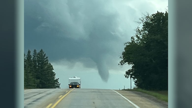
He headed out Wednesday night for a drive after seeing rotational patterns via radar that hinted at the possibility of a tornado.
"These storms do develop very quickly, so you have to keep a close eye on what's going on," he said. "Quite a few chasers in the area were reporting that there were funnel clouds or areas of rotation seen with the storm."
Kehler said he saw two funnel clouds himself, including one that dissipated as it moved east of Highway 206 on the east side of Birds Hill Provincial Park.
He saw another between Dugald and Oakbank.
"To my south I saw a funnel cloud, which was kind of between the Oakbank and Dugald, moving through some fields, so that one, I think ... will be confirmed as a tornado by the Northern Tornado Project," said Kehler.
"As it passed through those fields, there were some signs of damage on the ground."
Damaged land is one of the factors tornado researchers use to gauge whether or not a funnel cloud did touch down and become a tornado. If so, the extent of damage influences the rating the tornado gets under the enhanced Fujita scale (EF scale), a measure that reflects the size and intensity of a tornado.
Another telltale sign of tornado possibility is hail, said Kehler — something that had been corroborated as of Wednesday night by numerous accounts in southern Manitoba.
Robyn Dyck, a meteorologist at Environment and Climate Change Canada, said Steinbach received quarter- to loonie-sized hail. Stonewall had quarter-sized hail; St. Andrews was hit with loonie-sized hail; and Gunton reported hail from dime to golf-ball size, said Dyck.
"There were some really good photos, and by really good I mean that they looked like they were very close to the ground and on radar it looked very much like it could have been a tornado, but there will be more investigation," Dyck said early Thursday morning. "We had no confirmation of any tornado as of yet."
Tornado activity in Canada typically peaks in mid- to late-July, said Sills.
He said prior to Wednesday, Manitoba has had three confirmed tornadoes so far in 2025. That includes an E0 — the weakest rating on the EF scale — which touched down Tuesday in Grande-Clairière, southwest of Brandon, and didn't cause any damage, Sills said.
ABOUT THE AUTHOR

With files from Josh Crabb